Posts

History of St. Dominick – an occasional series: #5 Pre-history – 1485 Map 1: Part 4 Roman - Dark Ages: Indract & Dominica

Image
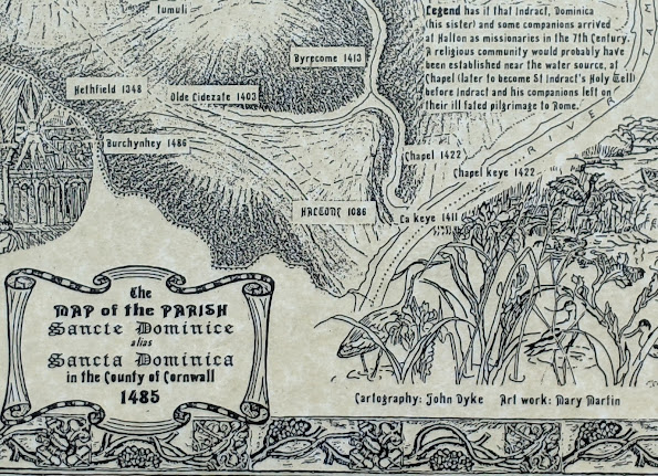
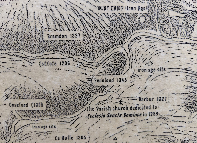
History of St. Dominick – an occasional series: #5 Pre-history – 1485 Map 1: Part 4 Romans to the Dark Ages and Indract and Dominica Part 4 (Romans AD 43 - AD410 Dark Ages 410 - 1066)Boldly stating Roman in this title suggests we have something Roman in St. Dominick. However, as far as I know we do not have any Roman remains … not even a few Roman coins turned up by metal-detectorists - unless someone can tell me different! I would not be surprised if something Roman was to be found somewhere in the Parish however, after all we border the Parish of Calstock and it isn’t far by river to the settlement at Calstock – and we now know there was a substantial Roman Fort in Calstock. This was only discovered, near St. Andrews Church on the hill above the town, in 2007. (Reference 1) I had the pleasure of joining in a community dig there in 2019 – more opportunities will be coming up as the dig area expands and the funding continues. This Roman Fort appears to have been in use betwe

History of St. Dominick – an occasional series: #4 Pre-history – 1485 Map 1: Part 3 Iron-Age

Image
  Part 3 Iron-Age The Iron Age (800 BC – AD 43) left more marks upon the landscape of the St. Dominick parish area. The most notable of these being at Berry Farm. Near the top of this section of map below - Bury Camp See section of map below: The change of name from ‘Bury Farm’ (with unrelated connotations as to its meaning - it is nothing to do with things or people being buried) to ‘Berry’ could be relatively recent – though it was written as Berry on the Tithe map (1841) it was still written as ‘Bury’ on the 1892 – 1914 OS map. Use the Reference (1) at the end of this post, to link into a side-by-side view showing the 1892 – 1914 Ordnance Survey map and an up-to-date satellite view. (you can copy and paste it into a separate window - or use control and click) A ‘Bury’ is the name given to a ditch and bank ‘fortification’ created during the Iron Age – and are sometime referred to as ‘rounds’ or ‘ camps ’ when of this smaller nature. The listing for the ‘Round at Be

History of St. Dominick – an occasional series: #3 Pre-history – 1485 Map 1: Part 2 (Bronze-Age)

Image
  Age (2500 – 800 BC). Up on Viverdon Down are a number of Bronze-Age bowl-barrows (burial mounds) Note: Barrow-burial is on a continuum from late Neolithic and through the Bronze-Age, and it has been noted in ref (3) that these would have also been visible from Balstone down. See map below:   Cornwall Council Strategic Historic Environment Service in their article on Bronze-Age monuments in Cornwall states “Some mounds are probably burials of important people. The largest barrows are in prominent locations on hilltops and ridges. The smaller barrows, which do not normally survive in lowland Cornwall, are inconspicuously sited amongst the fields and near the contemporary settlements.” and “ We can conclude that the many barrows found elsewhere in lowland Cornwall (eg. Cubert Common, Veryan Beacon) would have had round house settlements close by which are not now visible.” (1) Most of St. Dominick counts as ‘lowland Cornwall’. The earlier Bronze-age settlements were up on what we n

History of St. Dominick – an occasional series #2: Pre-history – 1485 Map 1: Part 1 (Neolithic times)

Image
The original of this project map was created by the late John Dyke, an artist and, during the second world war and before his retirement from the NT, a cartographer, who used to live in Bohetherick. On this map he included the streams and the river and dotted in the tracks that we believed would have been there by 1485, as they went from farm to farm or from these to the Mills, Church or the Manor houses. This was then shaded to show the hills in the manner used on very old maps, so that hills appear in semi-profile even though the map is in plan-view.                                     Section of Map 1 with added Neolithic detail outside parish boundary However, in prehistory – of course – there was no such designated area as our Parish, but what there was, most probably, were the streams and the river. From countries, to counties to parishes, natural features, such as rivers and streams have been used to delineate borders, and so it is with St. Dominick parish – and it is th

The History of St. Dominick – an occasional series: 1 – An Introduction

Image
Thank you to 'The Who'd' for creating this Blog for St. Dominick - I am sure that it will be a mine of information over the years. A bit of background: Those who know me (either as Ann Murphy or as my author name of Ann Foweraker: my maiden name) will know that I have had a lifelong interest in history, and in local and vernacular history in particular. When we moved into Radland in1983 I was determined to find out the history of that old house – and that also led me into glimpses of the history of St. Dominick itself.  However, it was the inspiration of The Parish Map Project (a Common Ground initiative) that led me to work with about forty people within the parish (with many doing the research, artists creating the illustrations and others providing services, like photocopying) eventually to collate everything and to create a series of maps illustrating the history of the parish. A section of the 1748 Parish Map Project If you were not involved, a little about th
  Welcome everyone to St Dominick blog. St Dominick is a village in the beautiful Tamar Valley in South East Cornwall. We are truly blessed to live somewhere which is surrounded with stunning vistas across a rural Cornish landscape. This a collective blog from our village including our community shop, local primary school, Cotehele our local National Trust heritage site, our parish newsletter, talented photographers, our locals, and ourselves- the local hostelry- the Whod Have Thought It Inn.   To start the blog ball rolling I’ll add a few words about who we are here at the Whod and what we do. Our small family comprising our daughter and two four legged friends made the move from Kent to South East Cornwall in the Autumn of 2019 to be the current custodians of the local pub. We have spent the last year and a half getting acquainted with our wonderful community and the Cornish weather! Clearly the curved ball we were not expecting was a global pandemic. It has brought with it both

Something from the archives ... sheep in winter

  If you see a sheep in the field, and it will be about this time of year generally when their fleeces are thick and heavy, and it’s lying on its back and waving its legs in the air it is NOT having a nice time playing. It is trying not to die and you can save it. Do not take your dog into the field. If the gate’s locked climb over it at the hinge end so you don’t damage it, then get hold of the sheep’s wool on its side and give it a heave, sort of rock it, so it can stand. Don’t be afraid of hurting it, it won’t hurt you, hopefully it will trot off in a most ungrateful manner.   If it doesn’t get up it could be dead already. Don’t be too upset, a farmer will tell you that dying is a sheep’s mission in life. You might need a bath afterwards.