History of St. Dominick – an occasional series: #3 Pre-history – 1485 Map 1: Part 2 (Bronze-Age)
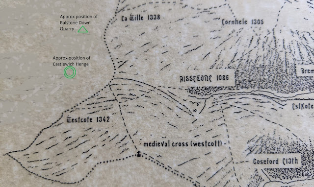
Age (2500 – 800 BC). Up on Viverdon Down are a number of Bronze-Age bowl-barrows (burial mounds) Note: Barrow-burial is on a continuum from late Neolithic and through the Bronze-Age, and it has been noted in ref (3) that these would have also been visible from Balstone down.
See map below:

Cornwall Council Strategic Historic Environment Service in their article on Bronze-Age monuments in Cornwall states “Some mounds are probably burials of important people. The largest barrows are in prominent locations on hilltops and ridges. The smaller barrows, which do not normally survive in lowland Cornwall, are inconspicuously sited amongst the fields and near the contemporary settlements.” and “We can conclude that the many barrows found elsewhere in lowland Cornwall (eg. Cubert Common, Veryan Beacon) would have had round house settlements close by which are not now visible.” (1)
Most of St. Dominick counts as ‘lowland Cornwall’. The earlier Bronze-age settlements were up on what we now term moorland – Roughtor, for instance, had a very large settlement, Bodmin Moor had many and their field systems can still be traced by low stone banks. The theory being that, as the soil in these areas became degraded by over use, they had to move onto the lower land, setting the pattern for farming today. Most lowland settlements, therefore, would have been created in the Middle Bronze Age (circa 1500-1200 BC) and were collections of circular houses.
However,
their monuments (the burial mounds) were still usually situated on
high-ground where possible, as Viverdon Down is, especially for important burials.
Historic England records this listing: “Two bowl barrows on Viverdon Down, 540m north west of Tipwell Farm - This monument, which falls into two areas, includes two bowl barrows situated on the summit of a prominent hill called Viverdon Down which forms the watershed between tributaries to the Rivers Lynher and Tamar. The barrows survive as circular mounds surrounded by buried quarry ditches from which the construction material was derived. The eastern barrow mound measures 18m in diameter and up to 1.2m high, the western barrow mound is up to 14m in diameter and 0.9m high.” (2) (This is noted as a ‘legacy listing’)
See below for a sketch of the cross-section of a typical bowl-barrow:

Though these barrows have not been investigated by excavation the construction of them has been observed by the Cornwall archaeology Society in 1994 when they visited. “Two barrows remain as prominent surface features, but erosion is being accelerated due to continued ploughing. The latter has nevertheless revealed the structure of the barrow mounds, with turf stacks capped with (now leached) orange clay presumably dug from encircling ditches.
This degraded capping forms a near-continuous ring around the larger, more northerly, barrow.Both within this ring and outside it, dark organic weathered blocks of turf indicate something of the former extent of the stack. Between the barrows, and slightly westwards, a further area of darker material in the ploughsoil suggests the former existence of a third, smaller, barrow.” (3)
Follow the link under (4) in the References, at the end of this post, to help you try to locate these on the satellite view of the area with ‘side-by-side’ maps.
The
question is, where is the settlement that sited these bowl-barrows on
the hill? Now, what follows here is supposition – but
the landscape around the hill is, even today, sparsely populated by
any ‘homesteads’ – but just off the crown of Viverdon Down (and on
the edge of St. Dominick parish) is ‘Tipwell’.

*[The name Towell – further into the parish - for instance, comes from the name At-Well (or AtteWell as it was written in the Manorial records) – so maybe that this is the origin of the name Tipwell too?]
A settlement at Tipwell would also have had the advantage of being near to the route of the ridgeway (discussed in the previous blog, here) – which would still have been in use at this time - and, if the hypothesis of the route also going down to the river is correct, it would be on that too - a well placed settlement.
However – as the Cornwall Council Strategic Historic Environment Service comments “the evidence of these lowland settlements have, largely, been completely ploughed away”(4) or, indeed, maybe the settlements themselves were just built over – so we may never be absolutely sure.
That is it for the Bronze-Age in our area – as nothing else I know of has been found and recorded – unless you know different, if so, please let us know!
Did you know there were Bronze-Age barrows on Viverdon Down?
Do you have any comments on this History of St. Dominick so far?
We would love to hear from you 😊
- Ann
References:
(1) & (4) Cornwall Council Strategic Historic Environment Service
(2) https://historicengland.org.uk/listing/the-list/list-entry/1004394
(3)
Cornish Archaeology No. 33 1994 (pdf)
Keith Ray: The barrow group at Viverdon Down, St Mellion: some observations on 24th April 1994
(4) Side-by-side maps to try to locate the barrows on satellite view (cursor and + sign show positions on corresponding maps)
Comments
Post a Comment