History of St. Dominick – an occasional series: #4 Pre-history – 1485 Map 1: Part 3 Iron-Age
Part 3 Iron-Age
The Iron Age (800 BC – AD 43) left more marks upon the landscape of
the St. Dominick parish area. The most notable of these being at
Berry Farm. Near the top of this section of map below - Bury Camp
See section of map below:
The change of name from ‘Bury
Farm’ (with unrelated
connotations as to its meaning - it is nothing to do with things or people being buried)
to ‘Berry’ could be relatively recent – though it was written
as Berry on the Tithe map (1841) it was still written as ‘Bury’
on the 1892 – 1914 OS map.
Use the Reference (1) at the end of this post, to link into a
side-by-side view showing the 1892 – 1914 Ordnance Survey
map and an up-to-date satellite view. (you can copy and paste it into a separate window - or use control and click)
A ‘Bury’ is the name given to a ditch and bank ‘fortification’ created during the Iron Age – and are sometime referred to as ‘rounds’ or ‘camps’ when of this smaller nature.
The listing for the ‘Round at Berry Farm’ (2), St. Dominick from Historic England reads:
“The monument includes a round, situated on the east-facing summit of a spur, overlooking the steep valley of a tributary to the River Tamar. The round survives as a roughly-circular enclosure defined by a rampart and largely buried outer ditch with a similarly defined annexe to the north west. The main enclosure measures approximately 65m in diameter internally. The rampart survives differentially, but reaches a width of up to 10m and an external height of 0.8m up to 2m to the north and west. To the south it has been incorporated into an existing field boundary. The annexe rampart has been partially fossilised within existing field banks, although to the north the rampart stands to a height of 1.7m above the accompanying ditch which is some 7m wide and 0.3m deep. Elsewhere it has been cut by farm buildings or is preserved as buried features” (1) (noted as a legacy record – first listed 1957)
The difference between the designation of a ‘Round’ and a ‘Hillfort’ is one of magnitude firstly. Locally we can easily see the difference between Cadsonbury just outside Callington (a Hillfort, on the top of a steep-sided hill, defended by a deep ditch (still 1.3m) and a high bank (still 2m internally) and the ‘Round at Berry Farm’ which is on the slope of a hill, at a point that makes a promontory over the stream valley, with steep sides only on the stream side. It too has a ditch and bank but was probably never as substantial as that of Cadsonbury, and encloses a much smaller area though with annexe attached (a squarish enclosure) which, it is thought, animals could be herded into if under attack. There is also a ‘captured-spring’ well house (much degraded) beside the lane that passes the Round at Berry, on the higher side, and only about a 100m away from it.
There wasn't much room for a large collection of houses within the space of a Round like at Berry, and it is possible that it was mainly the homestead of the local leader, a sort of clan chief, and his retinue, but also a refuge should the people under their protection be under attack. The people, mainly farmers would therefore live outside this enclosure on their own land, but paying tribute to the chief (who, in that culture, could be male or female) and both seeking refuge with them and fighting with them should their area be under attack from other clans.
See below – an artist’s impression by ©Mary Martin

As a side note - it is interesting to see that this land was given to the church, possibly by the Manor of Ashton in lieu of tithes or as a gift when the church was built to help support the minister, and was noted as Glebe land in the Terriers*(official church listing of possessions belonging to the Church) - as this was often the case with places where superstition surrounded what appeared to be 'strange land formations' (such as these appeared to be to the people of the time) so the safest thing was to give it to the church to deal with!
In 1994, whilst we were researching the History of St. Dominick for
the parish map project – the Cornwall Archaeology department
happened to send a team to do a ‘walking survey’ of St. Dominick,
and we were fortunate that they reported before we completed and sent
us a copy. From this we were able to put in some of the other details
they believed should be there – though now almost lost through
agricultural process. This suggested that there was another iron-age
bury at one time, across the stream from the Round at Berry. This
would have been on the promontory, with a steep drop to the
stream-side, below Pensingers Lane. The field shape in that area,
even now, shows as curved and it isn’t too hard to imagine an
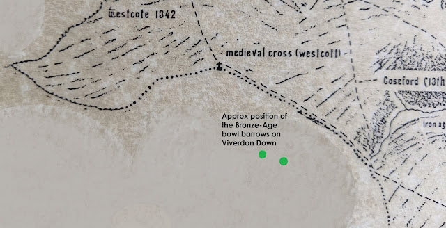
enclosure here. The higher of the two sites marked as 'iron-age site' on the map above.
Harder to imagine is the iron age enclosure they suggested they saw in topographical evidence for down below Trehill farm, overlooking the same stream, but where it is still quite small, with not such steep sides. The area suggested does show as having its own spring source, however, which a good sign for a settlement of sorts. The lower of the two sites marked as 'iron-age site' on the map above.

Of course - there may be other finds relating to this time that have been overlooked or are sitting on a shelf and never recorded. If you have something that could be from the iron-age do let us know!
Did you know there was an iron-age fortified round in St. Dominick?
Do you have any comments on this History of St. Dominick so far?
We
would love to hear from you
References:
(1) Side by side map 1892 – 1914 and satellite view
https://maps.nls.uk/geo/explore/side-by-side/#zoom=17&lat=50.49602&lon=-4.25504&layers=168&right=BingHyb
(2)Listing for Round at Berry farm, St. Dominick
https://historicengland.org.uk/listing/the-list/list-entry/1004393
Comments
Post a Comment